A Little
Wilderness
You may be
surprised to learn there are 8663 acres of land-locked, federally-designated
wilderness in Delaware, Maryland, New Jersey, New York and Pennsylvania . . . combined.

That statement needs some explanation. First, the land-locked part: There is a variety of federal wilderness areas in the Garden, Empire and Keystone states (sorry Delaware and Maryland). In the case of New York, it’s the Otis Pike Fire Island High Dune Wilderness and in New Jersey, the Great Swamp National Wildlife Refuge. Pennsylvania has the Allegheny Islands and the Hickory Creek Wildernesses. Of all these, Hickory Creek Wilderness alone is accessible by foot.
Second, this is it not to suggest Hickory Creek has a monopoly on Mid-Atlantic wildness. Can you say “Adirondack Park?” Covering some 6 million acres, New York’s vast mountain preserve dwarfs even Yellowstone National Park in size. However, with villages like Lake Placid and Saranac Lake – not to mention innumerable “camps” -- something like half of the land in Adirondack Park is privately owned. Heck, according to that infallible source of information on all things – Wikipedia – Adirondack State Park boasts more than 30 golf courses.

There are plenty
of other places between Toledo and the White Mountains to get lost in the woods,
of course. But only this tiny chunk of
the Allegheny Plateau between Tionesta and Warren, PA qualifies as
federally-protected wilderness. To
refresh your memory, the Federal Wilderness Act of 1964 defines a wilderness as an area where the earth and its
community of life are untrammeled by man, where man himself is a visitor who
does not remain. An area of wilderness is further defined to mean in this Act
an area of undeveloped Federal land retaining its primeval character and
influence, without permanent improvements or human habitation, which is
protected and managed so as to preserve its natural conditions and which (1)
generally appears to have been affected primarily by the forces of nature, with
the imprint of man's work substantially unnoticeable; (2) has outstanding
opportunities for solitude or a primitive and unconfined type of recreation;
(3) has at least five thousand acres of land or is of sufficient size as to
make practicable its preservation and use in an unimpaired condition; and (4)
may also contain ecological, geological, or other features of scientific,
educational, scenic, or historical value.

Nor is this
to say the 8600+ acres bordered by East and Middle Hickory Creeks is, strictly
speaking, forest primeval. The area saw
its share of logging in the 1800s and early-1900s; indeed, the principal trail
through the wilderness often traces old railroad grades and logging skids. However, commercial logging in Hickory Creek
petered-out in 1920s and the ensuing years have seen the flora and fauna inexorably
reclaim their turf, and the oil and natural gas wells that dot the surrounding 500,000
acre Allegheny National Forest are noticeably absent.
Thus, recent
imprints of man’s work were largely unnoticeable on the loop trail I recently followed
for a dozen miles through Hickory Creek Wilderness. Well-marked and gently undulating, it passes
through stands of mixed hardwoods – black cherry, oaks, maple and beech – with
an understory of ferns, along with the occasional cool grove of hemlocks and a
carpet of pine needles padding the path.
I also happened upon the odd meadow – whether “naturally occurring,” an
old clear cut yet to return to a forested state or a long-since abandoned
artillery firing range – where the dazzling sunshine contrasted to the woodlands’
dappled shade.

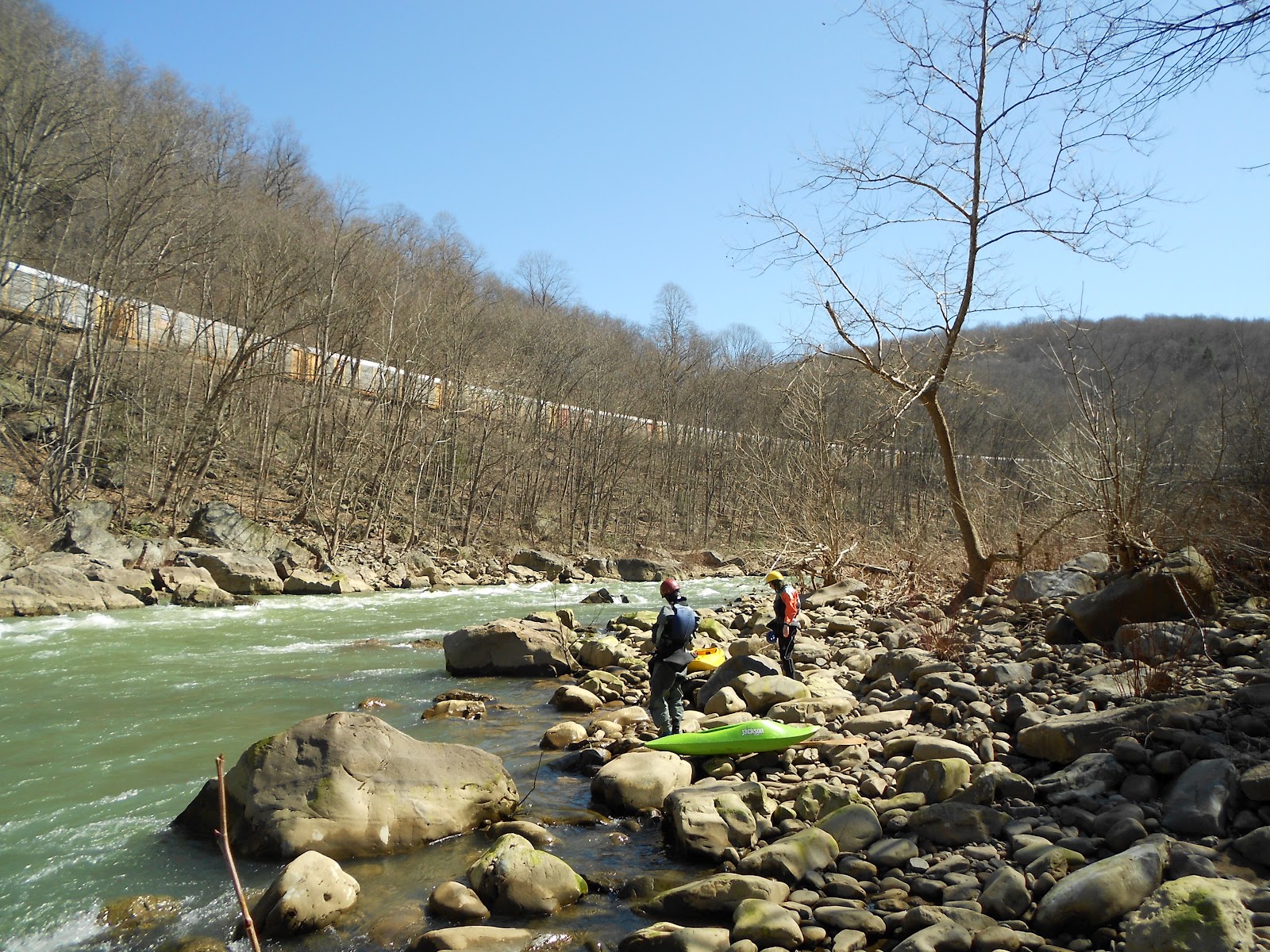
Although the
trail crosses an occasional stream or bog, there are only two substantial
watercourses – Jacks and Coon Runs – on the route. Just beyond the loop’s counterclockwise
mid-point, I came to the picturesque ford of Jacks Run, with deep pools along a
winding watercourse in a park-like setting with several primo camping
spots. Looking to make a relatively
quick exit from Hickory Creek the following morning, I continued on for another
mile or two to Coon Run.
Less
beguiling than Jacks Run, Coon Run passes through a brushy meadow bordered by a
marsh that looked ominously welcoming to mosquitoes, with a couple of
serviceable campsites tucked in a stand of oaks just a few paces off the
pathway.

A long day
of easy hiking gave way to a languid late afternoon in my Big Agnes Seedhouse,
alternating cat-naps with the simple pleasure of lying on my air mattress, gazing
at my surroundings through the tent’s fine mesh walls, protected from the
buzzing insects.
At the
trailhead I’d seen one fellow heading-off ahead of me and, later, encountered a
trio of hikers heading the opposite direction between Coon and Jacks Run. Camped by Coon Run, the late afternoon and
early evening passed without another soul passing by. And after a hearty meal of freeze-dried mac
‘n cheese and a liberal coating of DEET, I leaned my backpack against a tree
and spent the evening reading, turning-on my headlamp as dusk gave way to dark. Eventually, I repositioned my backpack in the
tent to prop-up my neck, read another chapter or two, then turned-in at the
civilized hour of 9 pm.

There was no rush for sleep; I was content to watch the night sky turn ever darker and stars begin appearing – Hickory Creek is, after all, not so very far from Cherry Springs State Park, “The Second International Dark Sky Park in the World” as designated by The International Dark-Skies Association.
Nor was the night’s entertainment limited to the visual senses. As Coon Run relentlessly splashed past, an owl sporadically hooted from deep in the woods. At times, the sound of jet planes drifted to earth, challenging me to find their pulsating lights among the stars and ponder their possible destinations, recalling how only a month ago I may well have passed over this miniscule spot on a red-eye from SFO to JFK.

Who needs television, radio or a page-turner when nature’s reality show is every bit as entertaining and infinitely more soothing.
The night passed in seamless episodes of slumber/sky gazing/listening. No worries of insomnia when you’re sure to get your fill of sleep -- for as long as it takes – in the alarm-less morning to come.