Thursday, March 15, 2012

The Path Not Taken

I doubt Robert Frost ever spent much time in Western Pennsylvania, particularly the outdoor playground known as the Laurel Highlands.  But last Sunday, on the first magnificent day of spring (even though it was a few days shy of the vernal equinox) half of the Mid-Atlantic states seemed to be out and about in Ohiopyle, the region’s recreational nexus.

Although fewer than 100 souls call Ohiopyle home the year ‘round (the 2000 census pegged the population at 77), the hamlet swells to many, many times that size on the weekends in the spring, summer and fall.  A few miles north of town, Fallingwater’s world-renowned beige and Cherokee red cantilevers hang suspended over Bear Run; a few miles south of town Frank Lloyd Wright’s lesser-known  Kentuck Knob is perched near the top of a hill overlooking the rounded mountains surrounding Ohiopyle, including the gorge of the Youghiogheny River – aka The Yough.

There are certainly more savage rivers in the United States, but none see more white water rafting than the Yough.   Even when the water is running high and swift – as it was last weekend – the rapids on the two mile stretch below the falls of the Youghiogheny (overlooked by Ohiopyle itself) are tailor-made for kayakers and rafters of all shapes, sizes and experience levels.  At least half a dozen commercial outfitters ply its waters, giving neophyte river runners a thrill or three, while scores of experienced kayackers delight playing in Cucumber, Railroad, Dimple and Double Hydraulic rapids . . . although a summer seldom passes that some unfortunate soul doesn’t drown after being tossed from his craft and getting stuck beneath the school bus-sized boulder that gives Dimple Rapids its name.

While the Yough has been drawing white water adventurers and entrepreneurs for half a century, Ohiopyle has only recently become a bicycling magnet.  These days scores of cyclists use Ohiopyle as the jumping off point for a day trip along one of the most scenic stretched of the Great Allegheny Passage bike path that stretches from Pittsburgh to Cumberland, MD, where it connects with the C&O Canal Towpath and on to Washington DC.

The path, which utilizes the abandoned railbed of the Western Maryland Railroad, parallels the Yough as it executes a nearly 360 degree loop downstream from Ohiopyle.   Along some stretches the bike path also utilizes (or usurps depending on one’s perspective) a network of footpaths paralleling the river. 

So it was that, on the first morning of DST, I set out on a Great Gorge hiking trail that sometimes runs in tandem with and “under” the bike path from its origins near the thundering falls of Cucumber Run down to Jonathan and Sugar Runs.

For much of the way, the Great Gorge path is delightfully easy walking, as it uses the railroad bed, with its wide, gentle and rock- and tree root-free gentle grades pleasantly meandering through a forest of pines and hardwood, with occasional rivulets plunging down the hillside towards the jade green Youghiogheny. 

About a mile into the trip though, a substantial bridge hoves into view on the right, one utilizing the weather-beaten pillars of an old railroad trestle connecting a spur to this mainline and now reborn as a foot/bicycle bridge for the Great Allegheny Passage.  Here you are presented with a Frost-like conundrum – take the bike path, a veritable forest freeway of crushed stone, gravel and sand, or the uneven, unpaved and less traveled Beech Trail climbing the slope above. 

It took me but a moment to select the Beech Trail, with its slightly more challenging nature and decidedly more intimate character.  Like the Great Gorge trail before it, the Beech Trail contours along the hillside, sometimes dipping under craggy outcrops, other times winding back along bubbling, rhododendrum-choked rills and, eventually, climbing to the point where stream crossings are better accomplished with a hop, skip and a jump than a costly bridge or culvert.

Eventually, however, the Beech Trail goes the way of the Great Gorge Trail, dropping to the level of, and merging with, the Great Allegheny Passage.  So be it.  Having seen just six people – and two dogs – on the bike path in the first two hours of my hike, it wasn’t like I was thrust into rush hour traffic upon joining the path more often taken.

In fact I only saw one other soul – a cheerful woman cruising past on a mountain bike – over the next mile or so, before I followed some wooden steps down towards the river and made my way to a rocky beach alongside Dimple Rapids.


Although I initially had the place to myself, I was soon joined by a rod-less fisherman, scouting the site for a planned visit with his grandson some future weekend.  And before long, one, two, three and, finally, oodles of kayakers paddled past, frolicking in the hydraulics before heading downstream to Swimmers, Schoolhouse rapids and the Yough’s rendezvous with Bear Run.  Several so enjoyed the experience, they paddled to shore, clambored from their kayaks and executed a gingerly portage along the rocky shore in their wet-suit moccasins only to button-back-up in their coffin-sized vessels and do it all over again. 

Before long, a low rumble announced the approach of a train.  Sure enough, a pair of diesel locomotives appeared across the river trailing a mile-long string of coal-laden hopper cars destined for the fossil fuel-fired power plants of the Midwest and what remains of Pittsburgh’s steel industry.

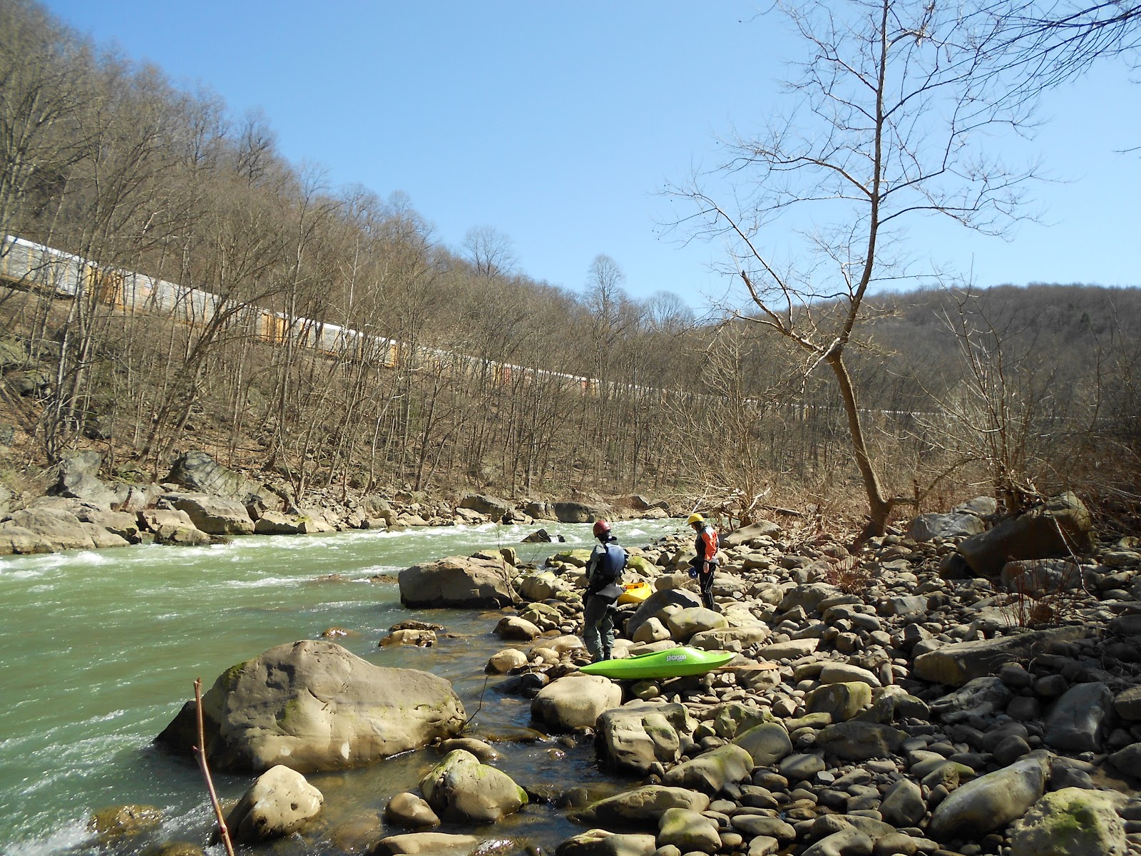
When it comes to Ohiopyle, the Youghiogheny and the Laurel Highlands, it seems there’s no end to the transportation options – be it trains, automobiles, kayaks, rafts, bicycles or the shoe leather express.  What’s more, sometimes those of us using the latter can have our cake and eat it too:  On the “back” part of my ‘out ‘n back hike,’ rather than retrace my steps along the Beech Trail, I stuck with the bike path and got the best of both worlds from my outing . . . even if Mr. Frost is rolling over in his grave!

Monday, February 27, 2012

Canyonlands, PA


Last September I spent a week in Canyonlands National Park, a week highlighted by a day hike to the remote confluence of the Green and Colorado Rivers and a backcountry overnighter to Druids Arch mixed with shorter explorations of various slot canyons and archeological sites from petroglyphs and Anasazi ruins to remnants of the early pioneer days. 

Last weekend I visited another remote confluence, two natural bridges and a “slot canyon” all within an hour’s drive of Pittsburgh, all within two miles of a trailhead in the rolling farmland of Western Pennsylvania. 

The particular locale is McConnell’s Mills State Park, home to what after Intercourse and Bird-in-Hand may be the butt of more jokes than any other locale in the Keystone state: Slippery Rock Creek.  The creek – which would qualify as a full-fledged river in many places – got its name from the Native Americans who found rocks near its headwaters quite, well, slippery thanks to the petroleum seeping to the surface; petroleum destined to be tapped by Edwin Drake in nearby Titusville, sparking the dawn on the petroleum age in 1859.

As you might deduce, McConnell’s Mill State Park is best known for the picturesque mill and covered bridge on Slippery Rock Creek just before it carves its way through a 600’ gorge en route to the Beaver and, later, Ohio Rivers. Understandably so.  The mill and bridge are the stuff of post-cards and, with an occasionally rugged trail running alongside the fast-flowing creek, a draw for hikers, canoeists, rafters, anglers, rock climbers and photographers alike.

Four or five miles downstream, Hell Run flows into Slippery Rock Creek after a trip down a less dramatic but more idyllic gorge lined on each side by trails.  The trailhead at the beginning of that journey offers little hint of the wonders to come.  To all appearances, Hell Run is little more (or less) than a stream meandering through a woodsy glen, steps away from farms whose livestock is audible for the first few hundred yards of the hike.  The trail quickly presents you with a choice: bear right to the Hell’s Hollow Trail or left for the very much longer and demanding Slippery Rock Gorge trail leading to the confluence of Hell Run and Slippery Rock Creeks and, ultimately, McConnell’s Mills. 

On the right fork you quickly enter a world apart, as Hell Run splashes over a series of ledges before carving through multiple thin bands of shale in a narrow, if not particularly deep “slot canyon.”  The shiny gray-black walls contrast with alternating carpets of dry brown leaves, brilliant white snow and velvety yellow-green moss decorated with crystalline icycles dangling from the rock layercake.  Further along, the watercourse crosses a broad shelf with barely enough water to dampen the whole expanse, creating a wafer-thin water sculpture in the bargain.

There’s much more to come.  A few yards further along the trail stand the remnants of a 19th century lime kiln.  A nearby staircase leads down to the water’s edge beside Hell’s Hollow Falls, a twenty foot cascade plunging into a shaded pool broken-up by a jumble of fallen trees and boulders – made treacherously slippery this day not by petroleum but a thin coating of ice.

And what of the trail on the other side?  Retrace your steps up Hell Run, cross a sturdy wooden bridge and you join the Slippery Rock Gorge trail, which happens to be a two mile segment of the North Country Trail, a “work in progress” that, when finished will stretch some 4,600 miles across seven states from South Dakota to New York and take its place alongside the Appalachian, Continental Divide and Pacific Crest Trails as one of America’s great long distance through hikes.

It’s hard to imagine any two miles of the North Country Trail will be more delightful than these.  While it’s hardly a rigorous two miles, there are ups and downs aplenty, some fairly steep, multiple stream crossings and not one but two natural bridges created by streams undercutting the limestone as they plunge to Hell Run hundreds of feet below. 

This time of year (and probably deep into April and perhaps early May) the natural bridges do double duty as ice caves, their dark interiors five or ten degrees cooler than the surface world and never seeing the light of day, at least directly.

Pressing-on, the omnipresent sounds of Hell Run are eventually drowned-out by a greater din, the sounds of Slippery Rock Creek.  Heard but not seen, Slippery Rock Creek is directly ahead as the trail makes a sharp left and heads towards Walnut Flats, the Eckert Bridge and, ultimately, McConnell's Mills.  This day, however, my destination is the confluence of Hell Run and Slippery Rock Creeks, a couple of hundred feet down a steep hillside on an unofficial trail.

From the moment I first laid eyes on the point of land between the two water courses several years ago, it’s been my ambition to camp there overnight.  It’s an ideal campsite, a flat, wooded parklet of sorts with lots boulders for shelves and seats around a spot that has obviously been used for many a campfire . . . as it is this day.  A trail of smoke rises to greet me as I clamor down the hillside and spy a man and three boys fishing nearby on Slippery Rock Creek.  Unless they intend to flout Pennsylvania Department of Conservation and Natural Resources rules, however, they will not be spending the night . . . although I can’t say the thought hasn’t occurred to me that it would be worth risking the wrath of the DCNR to slip in here with a tent and sleeping bag on my back just before dark some midweek summer’s evening.

No matter, it’s a perfectly wonderful place to spend an afternoon, lounging in the sun by the rushing waters of Slippery Rock Creek , or exploring the final quarter mile of Hell Run as it ends with the flourish of two elegant little waterfalls.

On a chilly winter’s day though, Slippery Rock Creek is no place for lounging.  It’s not so chilly as to discourage a leisurely lunch of PBJ, apple and Luna bar mind you, but it’s a far cry from the sun-drenched summer afternoons that have seen me doze away the hours listening to the waters hurrying towards the Ohio River.  

So with a wave to the fishermen of all ages, it’s a brisk climb back up the hill, over the natural bridges and through the woods to the trailhead . . . and back to a Pittsburgh few know lies just an hour away from the most beautiful natural bridges and slot canyon this side of Canyonlands National Park.    

Tuesday, February 14, 2012

Size Doesn't Matter


When it comes to appreciating nature, size doesn’t much matter.  No matter how big or small a natural feature, event or being, there’s always something else out there even bigger or smaller or, more importantly, every bit as compelling.

I was reminded of that fact while hiking through Cook Forest on Super Bowl Sunday.  Situated on the Clarion River in northwestern Pennsylvania, Cook Forest was established in 1927 to preserve some of the last remaining stretches of old growth forest in a state whose vast woodlands had been “harvested” by the timber industry in the 1800s.   Among the leaders in that timber industry was the Cook family whose scion – John – built a sawmill on 765 acres he purchased in 1828 at the confluence of Tom’s Run and the Clarion River. After his father’s death, Anthony Cook added two more sawmills to the business and prospered handsomely, but in the early 1900s the A Cook Sons Company began exploring ways of preserving some of the remaining virgin timberland.
In cooperation with the Cook Forest Association, A Cook Sons Company effectively “ate” the taxes on their forest holdings for more than two decades before the state legislature approved the purchase of the land – based on the condition that the Cook Forest Association raise the funds to purchase 6,000 adjoining acres.  That they did, and in 1928 Cook Forest became the first Pennsylvania state park dedicated to a natural landmark.

And what a natural landmark.   A hike along nearly any of the park’s 29 miles of trails quickly transports you into a primeval forest of towering white pines, hemlocks and hardwoods largely untouched by the ax or saw of Man since the earliest pioneers visited the area in the mid-1700s.  Those evergreens are among the tallest remaining trees east of the Mississippi, cresting 160’ and more above a floor carpeted in fallen pine needles and leaves, lush pockets of ferns and wind-downed trees covered in an emerald cushion of moss punctuated by various fungi and the first tentative sprouts of a new generation of trees that won't reach full maturity until the 22nd or 23rd centuries.

Of course, Cook Forest’s white pines and hemlocks would be little more than saplings in California’s groves of redwoods and giant sequoias.  But as I said, size doesn’t much matter when it comes to appreciating nature.  I can hardly imagine being more (or less) profoundly affected by a stroll through a grove of redwoods or sequoias than through the majestic calm of the Cook Forest’s “Forest Cathedral.”

Stand amid a stillness broken only by the tops of the evergreens softly hissssing in the high breezes and you can’t help but feel a sense of reverence, what Paul Woodruff calls “the capacity to be in awe of whatever we believe lies outside our control.”

Somewhere hereabouts stands the Longfellow Pine, said to be THE tallest tree in the northeastern United States at 182’.  I say “somewhere” as, unlike Sequoia National Park’s celebrated General Sherman tree (274.9’) for example, the Longfellow Pine stands in anonymity among its neighbors, no signs marking its presence, no trails directing visitors and hikers to its precise location.

Small wonder.  A glance around the Forest Cathedral reveals that, unlike the corrugated bark of the pines and hemlocks, the smooth trunks of many hardwoods have been (and continue to be) defaced by irreverent Kilroys whose egos are inflated by scratching their Lilliputian marks on the Ents of Cook Forest.  One can readily imagine what might befall (literally) the Longfellow Pine were its precise location widely advertised. 

But it is not only the towering evergreens which ought to trigger that “sense of awe at things outside our control” in Cook Forest.   A small chunk of wood lying among the giants felled by a 1956 micro-burst reveals a riot of swirling graining patterns of such incredible delicacy as to be worthy of any art museum – patterns no doubt endlessly mimicked but never quite duplicated in the tens of millions of board feet surrounding the Forest Cathedral.

Imagine the time and natural forces necessary to create such exquisite work.  Imagine further that it sprang from a seed that was, in turn, nurtured, shaped and – finally – brought crashing down by the sun, rains, snows and winds of two hundred or more springs, summers, fall and winters.   And that white pines, hemlocks, oaks, beech, maples, cherry and white ash almost beyond number have already taken its place and continue to thrive in this special corner of Pennsylvania called Cook Forest.   

Monday, January 30, 2012

It's (not) Only Natural

Upon hearing or reading the words "National Park Service" it's only natural to think of great American places like Yellowstone and Yosemite, the Grand Canyon and the Great Smoky Mountains.  These are, after all, the crown jewels of America's national park system, places that attract the lion's share of the more than 280 million people who visited the National Park System in 2010, places whose iconic features like Half Dome and Old Faithful grace oodles of calendars every year, places celebrated by Ken Burns in America's Best Idea.

But in terms of numbers (if not acres) the National Park System's National Battlefields (11), Memorials (28), Historic Sites (79) and Parks (42) outnumber its National Parks (58) and Monuments (74).  From the Gettysburg National Military Park and Big Hole National Battlefield to the Eugene O'Neill, Dwight D Eisenhower and Brown vs. Board of Education National Historic Sites, the NPS is as focused on preserving and celebrating America's remarkable history as its incomparable natural treasures.

So while one might not necessarily think of Western Pennsylvania and the National Park Service in the same breath, there are no less than half a dozen NPS sites in the western portion of the Keystone State, including the most recent addition -- the Flight 93 National Memorial near Shanksville.  In fact, the Flight 93 National Memorial is part of a diverse quartet of NPS sites scattered around the Laurel Highlands that includes the Allegheny Portage Railroad National Historic Site, the Johnstown Flood National Memorial and the Fort Necessity National Battlefield . . . in other words, two national tragedies, a seminal battle in the birth of the nation and one of the great technological marvels of the early 19th century are all commemorated and preserved by the NPS within an hour or two of Pittsburgh. 

In any case, as one who counts his visits to many of America’s great National Parks among the most enduring memories of his formative years, I’ve long harbored what (with each passing year) seemed increasingly to be a mere fantasy of someday working for the NPS.   Well, I’m delighted to say it’s no longer a mere fantasy.  No, I haven’t traded-in my iRacing, Penguins and Steelers ball caps for an official Smokey the Bear lid.  But I am now the proud possessor of an NPS Volunteer ball cap . . . and sweater . . . and polo shirt.

Last autumn, a trip that began as a hiking/backpacking adventure in the Colorado Rockies got snowed-out and I beat a retreat to the dry warmth of Canyonlands National Park.  There, while on a day hike to the confluence of the Green and Colorado Rivers, I fell-in with a seasonal NPS employee who explained the various levels/gradations of work within the system and urged me to explore volunteer work as a first step.  When I returned home I cast around not only to the local NPS sites but a couple of State Parks and was delighted to be welcomed to the Allegheny Portage Railroad (APR) National Historic Site by Gregory Zaborowski, the park’s gregarious head of volunteer programs.

I quickly received a primer on the APR, to wit, it was the lynchpin in a series of canals stretching from Philadelphia to Pittsburgh in the early to mid-1800s.  The APR featured ten steam engine-powered inclines used to haul the cargo and passengers up (and down!) the 1400’ heights of the Allegheny Mountains between Johnstown and Hollidaysburg.  In the its early years of operation, passengers and cargo were off-loaded from canal barges at each end of the portage, transferred to rail cars, hauled over the mountains and re-loaded onto canal barges on the other side.  Later, a system was devised where the barges themselves were loaded onto what amounted to flat-bed rail cars, eliminating the time-consuming off-loading/loading process.  Another improvement came when the ropes used to haul the cars on the inclines were replaced by a new fangled system of wire cables developed by a fellow named James Roebling.  In fact, the APR was the first large scale demonstration of the efficacy of Roebling’s cables, ultimately paving the way for their use in his Brooklyn Bridge.  Another first was the 900' long Staple Bend Tunnel, the first railway tunnel ever built in the United States.

It may sound like a helluva lot of work and effort to those of us used to driving between Pittsburgh and Philadelphia in 5 hours – or flying between the two ends of the state in less than an hour.  But in its day the Allegheny Portage Railroad cut the time it took to travel between the two cities from 26 to five days.  While the APR represented an immense advance in transportation, that day would prove relatively short. Improvements in steam engines ultimately enabled the railroads to overcome the Allegheny Mountains – with the help of the world-renowned Horesehoe Curve, itself just a mile or two away from the Allegheny Portage Railroad National Historic Site.

The bad news is that Gregory and I didn’t really connect until just a few weeks before Christmas or, in other words, after the Allegheny Portage Railroad National Historic Park goes into virtual hibernation for the winter.  Not that the employees go to sleep for three or four months.  The visitor center is open as are all the exhibits in the modestly sized main site, including the visitor center, Engine House #6 and the adjacent Lemon House Tavern where travelers including Charles Dickens, Jenny Lin and Harriet Beecher Stowe may have paused for refreshments (liquid and otherwise) while traversing the Alleghenies on the APR.  But with winds and snow whipping around the top of the Alleghenies, visitors are few and far between in the winter months.


The good news is that Gregory was able to give me a personal tour of the site and its environs, including the Staple Bend Tunnel located near Johnstown and now the highlight of a two mile hiking/biking trail.  Meanwhile, back towards Hollidaysburg stands the APR’s elegant Skew Arch bridge and another, more rugged, trail connecting Inclines 6 to 10.

I also learned the APR is heavy into historical re-enactments featuring employees and volunteers who dress in period costumes and perform tasks associated with the railroad including stone cutting, log hewing, rope making and blacksmithing.  As well, there are occasional “ghost tours” of the Staple Bend Tunnel and the Evening at the Summit series of musical concerts and presentations and concerts in the park’s amphitheater.  

Volunteers are encouraged to participate in any or all of the activities, be it dressing in period costume to hew a log or conduct tours of Lemon House, or just spending afternoons hiking or biking the trails and serving as a semi-official NPS presence in some of the APR’s far flung reaches.

Who knows how much (or how little) I’ll be able to do.  But I have a couple of months to bone up on the history of the Allegheny Portage Railroad . . . not to mention the Johnstown Flood.  For the Allegheny Portage Railroad National Historic Site and Johnstown Flood National Memorial are “sister” parks, staffed largely by the same NPS employees and volunteers.

So in the coming months, I’ll share some of my NPS volunteering experience with you.  It gives me yet another reason to look forward to spring!

Monday, January 23, 2012

Currier and Ives Meet the Kings and the Browns


It'll nearly be like a picture print
By Currier and Ives . . .

OK, the holiday season is rapidly receding in the rear view mirror, and hearing Nat King Cole croon “Sleigh Ride” for the umpteenth time may not be your cup of tea this late into January.

But it finally snowed in Pittsburgh for real on Friday, thus Saturday morning dawned on what, to my mind, is the closest thing to “a picture print by Currier and Ives” you’re likely to see anywhere – sled riding at the King Estate.

The King Estate (technically “Baywood”) is an elegant Second Empire mansion built by glass magnate Alexander King on several acres of land in the Highland Park neighborhood in 1880.   After wisely marrying into the Mellon family, King’s heirs donated Baywood and its grounds to the City of Pittsburgh in 1954 under the proviso that the mansion be torn down if the city was unable to properly maintain it. 

For the next forty years, as the city under-utilized Baywood to house arts and crafts programs for children and pre-teens, the once glorious building steadily deteriorated as a white elephant on the parks and recreation budget.  Sooner or later, the King family’s edict would surely have been enforced . . . until a local doctor and his pharmacist wife (Frank and Maura Brown) overcame fierce opposition from various neighborhood and civic groups to buy the joint in 1994 for the princely sum of $150,000.


While the Browns set about restoring Baywood itself to its former glory, the surrounding grounds remained in the city’s hands as a small but delightfully engaging park.  The principle geographical feature of The King estate is a “bowl” of land between Baywood and nearby Negley Avenue.  A semi-circular depression dipping down perhaps 50’ below street level (Nature’s perfect ¾ pipe?), it’s almost ideal for sled riding when the snow flies.  “Almost” is the operative word as, with sledders of all ages and sizes careening down its short but steep slopes from (nearly) all directions, it can resemble a near-circular firing squad on busy winter days.

And make no mistake, Saturday was a very busy winter day, with hundreds of kids (and the occasional Mom or Dad) sliding down the Bowl on sleds, inner-tubes and “saucers” as well as makeshift devices ranging from cardboard boxes to the odd cafeteria tray.  The sides of the Bowl were soon packed hard and, after a night of sub-freezing temperatures, Sunday with its slopes hardened to glacial consistency – making for even more thrilling descents.

Those who dared turn their back on the sledders, could follow the bottom of the Bowl where it funnels into a little glen of maples, ashes and hemlocks.  A trail leading into the trees showed evidence that several parents had, in all likelihood, towed their sled-sitting kids to a tantalizingly brief winter woodland experience beneath the gaze of Baywood and its outlying crenelated towers.  Make that crenelated tower (singular), as the battlements that once stood atop one of the towers now lie on their side near the bottom of the glen – sparking this visitor to muse upon the lives of Alexander King’s grandchildren who must have grown-up with, quite literally, a play castle in their backyard.

Deeper into the woods stands a trestle on the miniature railroad line running through the Pittsburgh Children’s Zoo and, buried under the snow somewhere is one of those urban mysteries: the rusting frame and parts of a drive-train from a mid-century Buick that someone, somehow contrived to drive into these woods.  How did it get there?  Who knows?  How do I know it’s a mid-century Buick?  Well, for openers the stout trees growing in the engine bay couldn’t be less than 40 years old . . . or so it seemed to me that last time I actually saw the old heap.  That would have been last summer, long before the snow flew and long before I couldn’t begin to find the car on my trip through the King Estate’s acre or so woods last weekend.

No matter, the old Buick will surely still be there the next time I tramp through the woods near Baywood.  Come to think of it, so will Baywood itself . . . thanks to the Kings of course, but mainly to the Browns and a city that recognized it was better to sell a magnificent white elephant to caring folks who could restore it to its former glory than simply expunging it from the books via the wrecking ball.